Saltfjellet National Park
The National Park is situated North of Mo i Rana. The park is 2,102 square kilometres (812 sq mi), and it's one of the largest national parks in Norway. It's also one of the most varied, since it includes both alpine mountain formations with glacier tongues, as well as gently sloping mountain plateaus and forested valleys. Mo i Rana is an excellent gateway to the park.
The National Park includes parts of the Saltfjellet mountain range, and Svartisen Glacier). The eastern regions where most of the hiker trails are located, is a flat and mostly easy going mountain plateau. The European Highway E6 and the railway Nordland Line also runs through the park. The Arctic Circle cross the southern part of the National Park.
For those who want to hike in the mountains there are a number of marked trails. You find accommodation opportunities on unstaffed tourist cabins, or you can stay in your own tent. The cabins in the park can be rented from Mo i Rana Trekking & Hiking association here. Hike in a beautiful scenery all year round. Winter is also great in the National Park, and with the right clothing and equipment, you can get an awesome ski trip in the mountain.
The wildlife is diverse, and the mountain has plenty of space to the large animals, that need the space around them to thrive. Moose, Reindeer, Lynx, Wolverine and the Arctic fox are common animals in the area. There is also a small number of bears and wolf on the mountain ranges. I's recorded about 120 bird species in the park including: Golden Eagle, Gyrfalcon, Eagle-Owl and Snowy Owl. There are also many lakes in the National Park.
Svartisen Glacier
Svartisen Glacier, which covers an area of 370 km ² forms a major part of the national park. The glacier actually consists of two parts: Western glacier that is 221 km2, and eastern glacier that is 148 km2. The highest mountain top is 1751 meters (5744 ft) and the glacier got a thickness of up until 450 meters. The glaciers lowest point over sea level is only 20 meters!
The name Svartisen comes from the old term black ice , which describes the characteristic deep blue color of the ice, with contrast to the white snow. In 1992 a laboratory was established 200 meters under the ice, and is the only one of its kind in the world. There the researchers have direct access to underneath of the glacier, where they can take samples of thousands of years old ice.
The Arctic Circle Center (Polarsirkelsenteret) is situated at the mountain range on approx. 670 Metres (2198 ft). Inside the Centre you will find a cafeteria, a cinema and exhibition hall with information about the Arctic Circle, and a large and abundant souvenir shop. It's open from 08:00 to 22:00 from May 20. to Sep 1. You can visit the center when driving your car over the mountain pass along the European Highway E6.
The train that crosses the mountain every day passing several stations on mountain that has request stop in the summer season. The train leaves from Mo i Rana several times daily and passing the stations Dunderland, Bolna and Arctic Circle Station. This provides a good starting point for further walks in the mountain national park. Remember to be well prepared as the area is very deserted.
If you are going to visit the glacier, then we recommend you travel to Meloy Municipality. There you find a large tourist center at the foot of the Glacier (Engabreen). There is a Shuttle Service that provides scheduled transport across Holand Fjord from the end of May until the beginning of September. The boat ride across the Fjord and only takes 10 minutes, and the boat departs from Holandsvika – just near the main highway.
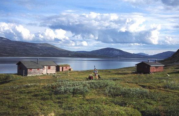
Saltfjellet National Park in Norway.
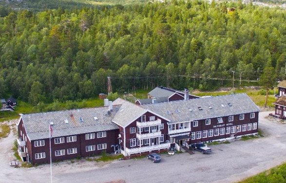
Arctic Circle Mountain Hotel.
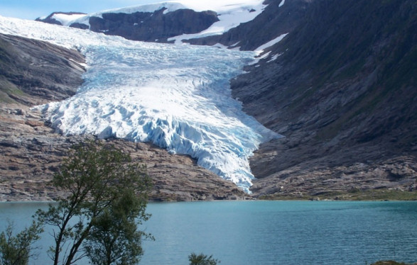
Engabreen Glacier in Norway.